|
https://christinafriedle.wixsite.com/gisdaypdx
We are excited to announce the 11th annual PDX GIS Day will be held at Ecotrust's beautiful and spacious Irving Street Studio on Wednesday, November 15th at 6:00pm. We are even more excited that renowned cartographer, Dan Coe will be the keynote speaker. Come for pizza, drinks, dessert, and to mingle with the local GIS community in this wonderful space. Please make sure to register so that we can get plenty of food and beverages. With a max capacity of 500, the Irving Street Studio has lots of space. The registration link can be found below. Please join your fellow geo-geeks to celebrate and share GIS! https://www.eventbrite.com/e/dvs-portland-making-numbers-count-with-karla-starr-tickets-722571078547? Join us for a talk, workshop and community building event with Karla Starr - acclaimed science and business writer, speaker and author of the book Making Numbers Count: The Art and Science of Communicating Numbers. Thank you to Ziba Design for hosting us in their beautiful auditorium! Registration is available here or in the PDX Data Visualization meetup group: https://www.meetup.com/pdx-data-visualization/events/296132905/ 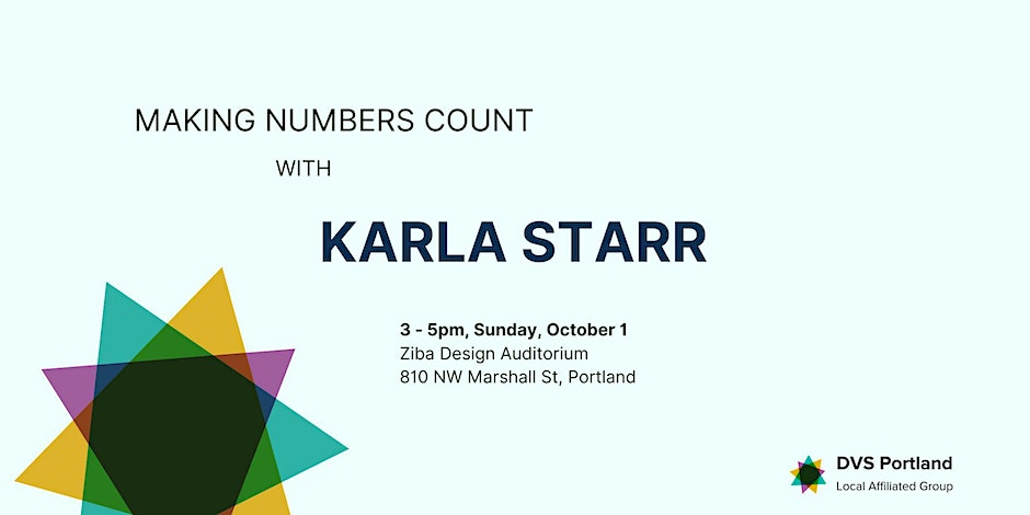 Join Esri and Freefly Systems for full day drone imagery workshop!
Whether you are new to using an unoccupied aerial vehicle (UAV) or you have been flying for years this workshop will offer tips and tricks for flight planning, image analysis, fleet management, and how to make shareable information products from drone imagery. The ArcGIS platform supports an end-to-end UAV workflow that can begin processing in both the cloud and in offline environments using desktop machines. We will demonstrate and discuss how to plan and use the autonomous flight planning software in the Esri platform to build imagery products from 2D and 3D GIS data. We will show the UAV created imagery products from different types of flights and the different types of processing that is available. We will also explore and explain how to configure these processing steps. After the imagery has been processed and we have created the derived products we will show how to analyze and share information using the ArcGIS platform. Additionally, Esri partner Freefly Systems will be presenting their Site Scan integration solution with the Astro drone. The Freefly Astro is a made in the USA solution to drone mapping. The Astro is compatible with Site Scan for ArcGIS and can carry a variety of imaging payload from 61-megapixel RGB cameras, to thermal, and Lidar units. Date: August 1, 2023 Time: 9am-4pm (Doors open at 8:30) Location: Esri R&D Center Portland 309 SW 6th Ave Ste. 600 Portland, OR 97204 Announcing the 12th annual
Spatial Lightning Talks Thursday, March 16, 2023 | online 10:00–11:45 am PDT | 6:00–7:45 pm CET Please register here and confirm your registration by clicking the link emailed to you upon registering. The Spatial Lightning Talks feature intrepid presenters who have three minutes to deliver their idea, story, or message. Topics may be wide ranging, as long as space—geographic or otherwise—figures prominently. Both serious and lighthearted presentations are welcomed, as long as they stick to the Ignite Talks mantra, “Enlighten us, but make it quick.” The event will be held online on Airmeet, which runs best in the Chrome browser. This year, we are again pleased to welcome presenters from across the US and several countries worldwide. Please feel free to share this invitation with colleagues and friends. Preliminary Schedule 10:00 am PDT | 6:00 pm CET
Round 2 (16 min.):
Round 3 (20 min.):
Round 4 (16 min.):
The Airmeet social lounge will remain open until 12:00 pm PDT / 8:00 pm CET for speakers and attendees to chat at virtual tables. Please direct questions to Kitty (kcurrier@ucsb.edu). How can maps, GIS and other geospatial approaches help students explore issues of social justice?
Join the Maps and Social Justice Convening: [eventbrite.com]Virtual Event: Feb. 9, 11 am - 2 p.m. EST The event starts with a series of short lightning talks from individuals and organizations working to create map-based content around issues of social justice. The lightning talks will be followed by breakout spaces to encourage conversation and connecting. Our goal is to build collaborations, learn about resources and strengthen pedagogical approaches in the hopes of stimulating conversation, resources and action. This workshop is geared toward those who work with K-12 teachers and students. We welcome participants from higher ed and informal learning as well. REGISTER [eventbrite.com] Organized by:
 We are thrilled to be able to bring PDX GIS Day back as a live and in-person event after a three year hiatus! This year is our 10th annual event in Portland and we are happy to have our Keynote Speaker, Lauren Sinclair, presenting "Let Them Make Maps!" The GIS Revolution in K12.
When: Wednesday Nov 16, 2022 Time: 6 - 9 pm Where: Ecotrust Building What: GIS community, speaker, pizza, beer & wine, beverages, prizes & cake Website: https://christinafriedle.wixsite.com/gisdaypdx Register: https://www.eventbrite.com/e/gis-day-pdx-2022-tickets-444228418157 GIS Day PDX events are open to everyone and FREE. This event is only possible thanks to the generous support of our sponsors: NV5, SWCA Environmental Consultants, the Gartrell Group, PCC, Ecotrust, Esri, URISA, NSF and PDX-OSGeo. Thanks so much! Hope to see you there. Please see the flyer below for PSU's upcoming Back to School Night event! We will have snacks, some information about the PSU GIS club, and some presentations about recent projects and opportunities from fellow PSU GIS folks. When: Monday, 10/24, 4-6PM Where: CH 418 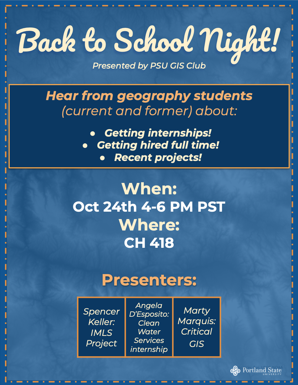 It's been over 3 years since a Portland Area GIS User Group meetup and it's finally time again to connect with our local geospatial professionals, students, and enthusiasts! This GIS social is a collaboration between Portland Area GIS, Emerging Professionals, and Esri. There will be peer presentations on all the great GIS and technology innovations happening in the Portland area. Food and beverages will be provided by Esri and we will have a tour of their new R&D office digs in downtown Portland that just opened up for operation. Look forward to seeing you all there! Please RSVP by registering for the event.
https://www.orurisa.org/event-4946256 Day/Time: September 14, 2022 1:00 - 3:30pm Location: Esri R&D Office Atrium in Main Lobby 900 SW 5th Ave, Portland Rather attend virtually? We're looking into options for the presentation portion of the event and will post more info here soon. ORURISA Portland Area GIS Users Group - PAGIS The Portland Area GIS Users Group (PAGIS) provides a forum for GIS professionals, students, and others interested in GIS to meet, share ideas, view demonstrations, and participate in technical discussions. We are a network of people in the GIS community of the greater Portland area and believe that we can all learn from each other and improve our job performance. The User Group provides a means and opportunity for users to get to know one another and exchange information and expertise. Anyone with an interest in GIS can attend meetings -- or present. |
Categories
All
Archives
March 2024
|
 RSS Feed