|
Closing date: 2024-05-05
Position: Conservation Technology Associate, California Organization: The Nature Conservancy Country: United States State: California Contact: Brian Cohen Contact Email: applyhelp@tnc.org https://careers.nature.org/psp/tnccareers/APPLICANT/APPL/c/HRS_HRAM_FL.HRS_CG_SEARCH_FL.GBLPage=HRS_APP_JBPST_FL&Action=U&FOCUS=Applicant&SiteId=1&JobOpeningId=55015&PostingSeq=1 Description The Conservation Technology Associate's work will support every program and many conservation strategies across TNC California, and will entail collaboration with many Conservation Technology colleagues. This role is responsible for processing spatial and relational data sets, performing data analysis, and creating cartographic and data visualization products. They also build, maintain, and populate data and record databases, and maintain a shared GIS library and database products library. Their role includes developing, analyzing, and managing data sources in various formats. They digitize and clean large datasets, manipulate data, and conduct quality assurance reviews and tests on data. They provide spatial analysis, maps, charts, and reports to support planning and prioritization efforts, and publish data to the web, creating web maps and web applications. They assist the team with project management as needed and curate GIS data, Esri .aprx documents, and Python code. May work in variable weather conditions, at remote locations, on difficult and hazardous terrain and under physically demanding circumstances. About Organization The Nature Conservancy (TNC) is a global conservation organization dedicated to conserving the lands and waters on which all life depends. Grounded in science, we develop innovative solutions to the world’s toughest environmental challenges so that people and nature can thrive. Our work is guided by our values, which include a commitment to diversity; respect for people, communities, and cultures; and a collaborative, nonpartisan approach. Thanks to more than 1 million members, over 400 scientists, and the dedicated efforts of our staff and partners, we impact conservation around the world. The California Chapter is TNC’s largest state program and one of the largest, most dynamic conservation organizations in the country. With approximately 275 employees, from financial analysts and fundraisers to ecologists and economists, we are currently invested in 14 strategies to address the biggest challenges facing California and the world, including numerous community-based projects designed to increase the pace, scale, and effectiveness of conservation. Over the past six decades, we have protected 1.4 million acres, 5,000 miles of streams, and 3.8 million acres of ocean habitat in California and off the coast. The California Chapter believes that we are most effective when we are embedded in our state’s communities, politics, media, and environmental issues. For this reason, and to reduce our carbon footprint when meeting in person, all staff live in California, including those in a home office. Finally, we are passionate about the middle ground in American politics and life. The hallmark of The Nature Conservancy is its “big tent” approach, engaging people across the political and ideological spectrum to find solutions that last. We ask all employees to embrace this critical strategic position of our organization. The National Park Service, Alaska Region, just announced a 6-month (plus) internship opportunity to assist with GIS in support of a stream restoration project in Yukon-Charley Rivers National Preserve. See the attached announcement for details. Applications due by April 20. https://www.suu.edu/iic/internships/ 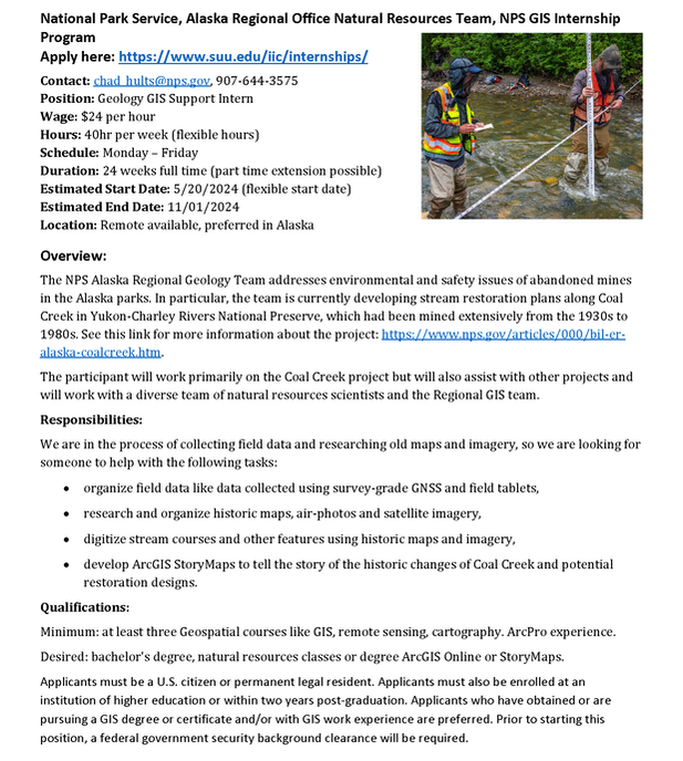 GIS and Data Systems Specialist (TPS4) w/ State of Washington Dept. of Transportation (Seattle)4/9/2024
About WSDOT
Washington State Department of Transportation (WSDOT) is the steward of an integrated, multimodal transportation system that helps to ensure people and goods move safely and efficiently throughout the state. In addition to building, maintaining, and operating the state highway system, WSDOT operates the largest ferry system in the nation, manages the world's longest floating bridge, and recently completed the world's widest tunneling project. The Opportunity WSDOT’s Active Transportation Division is currently seeking a Transportation Planning Specialist 4 to serve as a GIS and Data Systems Specialist in Seattle, WA. This specialist will serve as the geospatial data development and data management lead for the division, and provide analytical support for capital projects, active transportation funding programs, and other programs serving active transportation users. The top candidate will also provide general geospatial and data analysis support to the Active Transportation Division including establishing and facilitating effective data storage and retrieval systems, consistent with lean data principles, industry best practices, and agency geospatial data standards. Additionally, this position will serve as the liaison to WSDOT’s Transportation Data and GIS Office (TDGO) and Technology Services Division (TSD) groups and as the agency’s trails and paths data coordinator. What to Expect This is a highly collaborative position, involving teams both inside and outside of the agency. The chosen candidate will have a central role in shaping active transportation data development and data management for the agency. Many tasks will require creative solutions and iterative approaches to both support ongoing agency work and to advance the state of practice with respect to active transportation data and geospatial analysis. Among the varied range of responsibilities held within this role, the GIS and Data Systems Specialist will:
Qualifications To be considered for this opportunity, the following are required:
It is preferred that qualified candidates also have:
Important Notes
Why WSDOT
HOW TO APPLY: https://www.governmentjobs.com/careers/washington/jobs/4455480/gis-and-data-systems-specialist-tps4 Due to the specialized nature of this work, we are going to leave this recruitment open until May 31, 2024 with the first review of applications beginning at 8AM on April 15, 2024. Please note, this recruitment may close anytime after that first review date.
If you enjoy the outdoors, Oregon’s Willamette Valley is the place for you. It is less than an hour from glaciated mountain peaks to the east, the Pacific Ocean to the west and the massive Columbia River Gorge to the north. You can fish 365 days a year, and there is hunting for big game, waterfowl and game birds. The Oregon coast attracts thousands of people who clam, crab and fish in the ocean for halibut, salmon and tuna. The outdoor opportunities are endless when it comes to fish and wildlife in Oregon! If culture is what you seek, the Willamette Valley is the most populated area in Oregon and contains its three largest cities: Salem, Portland and Eugene, which are home to many museums and theaters. The Valley is also known for its vineyards, breweries and fantastic casual dining experiences. To learn more about the department and the work we do, view the following video at https://myodfw.com/about To see examples of some of the maps we produce, please visit https://www.dfw.state.or.us/maps/index.asp What you will do:
Working Conditions
Criminal Records/DMV Check Applicants are subject to both a criminal history and motor vehicles check. Out-of-state finalists will be required to present a current certified driving record for review to be considered for the position. Be prepared to obtain as soon as possible. You are expected to provide the out-of-state certified driving record before an offer can be made unless extenuating circumstances exist. Adverse background information may disqualify you from further consideration. NOTE: Within three days of hire, applicants will be required to complete the U.S. Department Homeland Security's I-9 form confirming authorization to work in the United States. ODFW participates in E-Verify. ODFW is not able to support VISA sponsorships. We are seeking applicants who meet the minimum qualifications and have the following skills and experience: Minimum Qualifications:
Requested Skills:
HOW TO APPLY: https://oregon.wd5.myworkdayjobs.com/en-US/SOR_External_Career_Site/job/Salem--ODFW--Headquarters/Information-Systems-Specialist-4--NRIMP-GIS-Technician----Temporary_REQ-153300 https://conservationdistrict.org/2024/new-weedwise-technician-2024.html
WeedWise Technician (Seasonal)The WeedWise Technician is a full-time, seasonal (1040 hours), at-will position that will assist with surveying and managing invasive weeds. Successful candidates will assist with WeedWise Program activities and initiatives as required. Successful applicants will demonstrate:
Additionally, successful applicants will have:
Closing date: 2024-04-19
Position: Spatial Analyst Organization: Earth Insight Country: United States State: California Contact: Bart Wickel Contact Email: hiring@earth-insight.org Description: Spatial Research Analyst We are seeking a highly motivated Spatial Analyst to support the development of spatial tools and analytical approaches to qualify and quantify the future threats and ongoing impacts posed by future extractive industry development. The Position: The Spatial Analyst reports to the Science and Research Director and works collaboratively with other team members to gather, process, and analyze spatial data, and produce high-quality maps, novel visualizations and reports. You will also assist with the preparation of communication products that support Earth Insight’s engagement efforts with partner organizations and at key international fora including but not limited to Conference of Parties (COP) of the United Nations Framework Convention on Climate Change (UNFCCC) and the Convention of Biological Diversity CBD). The ideal candidate has a can-do attitude, is committed to contributing to meaningful change at a local to global level and has a curiosity about exploring new methods for analyzing and visualizing data. Demonstrable experience with Geographic Information Systems (GIS) is required and familiarity with open-source tools and libraries for spatial analysis and management and web mapping (e.g. Leaflet, Mapbox etc.) strongly appreciated. This is a full-time exempt position and is open to those authorized to work in the U.S. The position is fully remote based in the U.S. Key Responsibilities: - Perform data collection, analysis, and visualization using QGIS and other GIS software - Manage and maintain spatial databases, including data entry, data quality control, and data organization - Conduct spatial/GIS based data analyses to identify the threats associated with mining, oil and gas development and other drivers impacting local to global ecosystems, climate, biodiversity, and people - Produce high-quality maps, innovative data visualizations, and reports - Work collaboratively with other team members to provide support for various projects and cross-program priorities (ex: press strategy) as needed Qualifications: - Bachelor’s or Master’s degree in Geography, Environmental Science, or related areas - Demonstrable experience with GIS software, specifically QGIS and related software packages (QGIS/GDAL) - Demonstrable experience with at least one scripting language (Python, R, etc.) - Strong analytical and problem-solving skills - Excellent written and oral communication skills - Ability to work independently and as part of a team - A strong interest in environmental justice issues - Willingness to work on an adaptive schedule to accommodate calls with project partners across different time zones as needed Diversity, Equity, and Inclusion: RLF is committed to creating and maintaining a work environment free from discrimination, where all team members feel valued, respected, and included. We are an equal opportunity employer and welcome applications from all qualified candidates, whatever their race, color, creed, national origin, ancestry, sex, gender, sexual orientation, age, disability status, religious or political affiliation, marital status, or any other dimension of diversity. We know that our work is enriched by the varied voices and perspectives of every staff and board member, so we are committed to making an earnest effort to recruit, welcome, train, develop, and retain talented individuals from diverse backgrounds. We believe that a diverse and inclusive culture expands our creative capacity to do our work and achieve greater outcomes for people and the natural world. We invite you to learn more about RLF’s commitment to diversity, equity, and inclusion on our **[website](https://resourceslegacyfund.org/diversity-equity-inclusion/)**. Compensation: RLF is committed to providing competitive compensation and a total rewards package that emphasizes both base salary and comprehensive benefits. The starting salary range for this role is $65,000-$85,000. Offers are based on qualifications and experience and our practice of maintaining salary equity within our organization. We have an alternate Fridays off work schedule (employees work 40 hours one week, 32 hours the next week) and offer a comprehensive benefit package including medical, dental, and vision insurance, 401k plan with up to a 5% match, and generous paid time off including approximately 17 paid holidays per year. RLF also offers a technology allowance, student loan repayment assistance, the Calm app, mental health benefits, and fertility and adoption/surrogacy benefits. To Apply Please provide a resume, map product and/or coding portfolio (e.g. github, map stories etc.) and cover letter in PDF format explaining how your skills and experience align with this position to [hiring@earth-insight.org](mailto:hiring@earth-insight.org) and specify your name and position you are applying for in the subject line. The application deadline is April 19th, 2024. About Organization About Earth InSight and the Resources Legacy Fund: Earth Insight’s mission is to create transparency in existing and future plans for the expansion of extractive industries (fossil fuel extraction and mining specifically) and map potential threats to people, nature and climate in the world’s most vulnerable and intact places. Through the development of web-based mapping tools and innovative analytics founded on open-data and open-access data and code, we aim to arm communities and the environmental movement with ways to increase political and financial pressure and stop new fossil fuel and other destructive extractive industry developments, while charting alternative development pathways that respect biodiversity, human rights, and a stable climate. Earth Insight is a fiscally sponsored project of Resources Legacy Fund (RLF) based in Sacramento, California. RLF builds alliances that advance bold solutions to secure a just and resilient world for people and nature. RLF partners with philanthropy, community groups, government, science, and business to promote smart policies and ensure equitable public funding that protect nature, address the climate crisis, and advance environmental equity and justice. Across the American West and internationally, RLF manages complex, multi-year grantmaking programs and fiscally sponsored projects that accelerate change on environmental and equity issues. About the Position
The GIS Analyst is responsible for the operation and maintenance of the District’s Geographic Information System (GIS) and work order management systems, and for providing a high level of technical support, and services to personnel in digital mapping and District asset management. NOTE: Based on qualifications and experience, candidates may be considered for either the GIS Analyst or Senior GIS Analyst position. (Click the link to Senior GIS Analyst for a full job description) Essential Duties and Responsibilities include the following. Other duties, responsibilities, and activities may change or be assigned at any time with or without notice.
Position Requirements To perform this job successfully, an individual must be able to perform each essential duty satisfactorily. The requirements listed below are representative of the knowledge, skill, and/or ability required. Reasonable accommodations may be made to enable individuals with disabilities to perform the essential functions. Supervisory Responsibilities: This position has no supervisory responsibilities. Education and/or Experience: Associate's degree in geographic information systems, geography, planning or computer science; and a minimum of three (3) years of experience related to GIS systems; or equivalent combination of education and experience. Utility experience preferred. Certificates, Licenses, or Registrations: Must have a valid Driver’s license. ESRI Technical or GISP Certification preferred. Computer Skills: To perform this job successfully, an individual must be proficient in MS Outlook, Excel, and Word. Experience with ESRI, relational database management, and Internet-based applications preferred. Physical Demands: The physical demands described here are representative of those that must be met by an employee to successfully perform the essential functions of this job. While performing the duties of this Job, the employee is frequently required to walk, climb stairs, bend, reach, use hands to finger, handle, and feel, and sit for extended periods of time. Occasionally required to lift and carry up to 40 pounds. Required to speak and hear clearly when communicating over the telephone and in person. Work Environment: The work environment characteristics described here are representative of those an employee encounters while performing the essential functions of this job. While performing the duties of this job, the employee is regularly exposed to indoor and outdoor environments. Outdoor settings include all types of property and site conditions including open spaces, timberlands, urban developments, flat and hilly terrain, building construction sites, and road rights-of-way. The noise level in the work environment is moderate. HOW TO APPLY: https://www.governmentjobs.com/careers/lcpud/jobs/4447656/gis-analyst-or-senior-gis-analyst To The Point Land Surveying, LLC, located in Rogue River, Oregon was established in 2012. We are a family-run, well-respected land surveying company. At To The Point, we take pride in offering our client excellent surveying services, in a timely manner, and at a fair price. We work throughout Alaska and Oregon.
We work on:
We have an open position for a full-time Land Surveying Technician. Ideal candidate has 2-3 years of field crew experience. Candidate must also have the ability to work in all weather conditions, outside all day, work safely in traffic conditions. Must have knowledge of Robotic Total Stations, data collectors, basic knowledge of RTK GPS Receivers, Windows and Word applications and some use of AutoCAD. We seek an employee that has a positive attitude, team player, able to pass a background check and has a valid driver’s license. We live in a beautiful place and find it is a benefit to our employees to offer a flexible work schedule. We offer a good benefit package with vacation, holiday, and sick pay. Compensation is dependent upon the candidate’s experience and skill set. To learn more about To The Point Land Surveying, LLC and what we do, please visit our website at www.tothepointls.com. To apply, provide your Letter of Interest, Resume, and 3 references to: jason@tothepointls.com or send to 230 East Main Street, Rogue River, OR 97537 If you have questions, feel free to call us at (541) 855-4280. https://www.governmentjobs.com/careers/portlandor/jobs/4443147/surveying-aide-ii
Job Appointment: Full-Time Work Schedule: Monday - Thursday 6 am-3:30 pm, alternate Fridays 6 am-2:30 pm or off. Work Location: This position will require the selected candidate to work in person from either the Soil Testing Lab Facility (Transportation) or the Interstate Campus (Water). Both facilities are located close to downtown within the inner North Portland area. Benefits: Please check our benefit tab for an overview of benefits for this position. Union Representation: District Council of Trade Unions (DCTU). To view labor agreements, current and future, please visit the Current City Labor Agreements page. Application Material: Please click APPLY to submit your application via the City of Portland’s online portal. You will need to respond to the supplemental questions and attach a resume. About the position: Surveying Aide II assists a Survey Crew leader working on mapping, construction, monitoring, and boundary/right-of-way projects for various City Bureaus. A Surveying Aide II and crew members often work in high-traffic areas and projects crossing rough terrain and help ensure the safety of themselves and their crew. What you’ll get to do:
An Ideal Candidate will have knowledge of how to operate current survey instruments, computers, standard software, and file management practices. Who you are:
About the bureaus: The Portland Bureau of Transportation is a community partner in shaping a livable city. We plan, build, manage, and maintain an effective and safe transportation system that provides people and businesses access and mobility. We keep Portland moving. For more information about the Portland Bureau of Transportation, please visit www.portlandoregon.gov/pbot. The Portland Bureau of Transportation embraces diversity, models inclusivity, and promotes equity through its service delivery, internal operations, organizational culture, and in its work with partners and the community. The Portland Water Bureau's 600 employees work together to serve almost a million people in the Portland Metro area. The bureau values a diverse workforce and seeks ways to promote equity and inclusion within the organization and with the public. Our mission: We serve excellent water every minute of every day. Our vision: The water our community loves is safe and abundant for generations to come. Our equity commitment: work to uproot systemic inequities and their impacts on our employees and the people we serve. We commit to the difficult—and essential—work of transforming Water Bureau policies, practices, and culture to better serve historically and currently oppressed communities. More Information about the bureau: www.portlandoregon.gov/water Applicants not currently employed by the City of Portland start at the entry salary rate. If you are a DCTU-represented employee, see the labor agreement for additional information or talk to your union representative. Questions?: Terrol Johnson Senior Recruiter terrol.johnson@portlandoregon.gov To Qualify Applicants must provide details in their supplemental question responses and resume that demonstrate how their education, training and/or experience, meets each of the following minimum qualifications:
Purpose
Performs data collection and validation, supports initiatives of the Water, Sewer and Storm Comprehensive Plans and assists with Engineering Vault scanning and organization. Schedule/Duration: Up to forty (40) hours per week for a maximum of six (6) months. Qualification Requirements
City of Wenatchee Government The City of Wenatchee is a full-service City employing 190 employees. In addition to Information Technology, other departments include Public Works, Police, Parks, Recreation and Cultural Services, Finance, Human Resources and Community Development. The City operates under a Strong Mayor form of government with seven council members. Active boards and commissions advise the City Council with governance. The Community The City of Wenatchee is home to 35,405 people with 116,178 living in the greater Wenatchee area. Located in a beautiful valley at the confluence of the Wenatchee and Columbia Rivers and on the east slopes of the Cascade Mountain Range, the city enjoys abundant sunshine with four distinct seasons. The average rainfall is a mere 10 inches per year making the region a focal point of Washington State for outdoor recreation. Wenatchee is the largest city in rural North Central Washington and thus provides a small-town atmosphere with big city amenities striking a great balance between rural and urban qualities of life. Must See: “We Are Wenatchee Part I” https://vimeo.com/88411706 “We Are Wenatchee Part II” https://vimeo.com/121429638 “We Are Wenatchee Part III” https://vimeo.com/208608170 Our historic downtown is a nationally recognized Main Street with an active downtown association http://www.wenatcheedowntown.org. HOW TO APPLY To view the job description and complete an online application please visit: https://www.governmentjobs.com/careers/wenatcheewa. Initial Review Date: 5:00 P.M., Monday, April 15, 2024. Open Until Filled. |
Categories
All
Archives
March 2024
|
 RSS Feed