|
https://conservationdistrict.org/2022/conservation-specialist-term-position-announcement-2022.html
Conservation Specialist This is a limited-duration, grant-funded position lasting two years with the possibility of renewal contingent on future grant awards. Successful applicants will:
The Conservation Specialist evaluates natural resources (soil, water, animals, plants, and wildlife) on rural properties. They provide planning and technical assistance to individual landowners for the successful development and installation of conservation practices to conserve natural resources. The person in this position is an integral member of the District’s conservation planning team. The Conservation Specialist is expected to provide superior customer service and behave in a professional manner. JOB ANNOUNCEMENT – Aerial Mapping Company
POSITION: Aerial Mapping Technician Portland (Sellwood) Oregon location TYPE: Full Time (F/T) with Benefits GeoTerra, Inc. is a full-service aerial mapping company with offices in Portland, Eugene, and Boise with an aircraft hangar facility at Aurora State Airport, 20 minutes south of Portland. As a leader in the Remote Sensing field, the company enjoys a great reputation and history of success in the Northwest. GeoTerra supports a wide variety of private and government entities across the United States with imagery acquisition, photogrammetric mapping, orthophotography, and geospatial services. GeoTerra is recruiting an Aerial Mapping Technician to serve in the Sellwood (Portland) location. The successful candidate for the Aerial Mapping Technician position will:
Secondary Duties: The ideal candidate would be trained as a Sensor Operator in GeoTerra aircraft and occasionally utilized for Aerial Acquisition tasks. This task requires a moderate amount of physical agility and willingness to work weekends (pre-scheduled.) A Sensor Operator is responsible for the aerial photography and LiDAR sensor systems and assisting the pilot, as needed. No previous experience with aerial sensors is required but the person should be very comfortable with operating a computer system. Experience with geographic information systems (GIS) software is a plus. Benefits:
If interested, please forward resume and cover letter to: GeoTerra, Inc. Attn: Debbie Hazell [email protected] If you have questions, please contact Debbie at 541.343.8877 GeoTerra, Inc. is an equal opportunity employer. GeoTerra does not discriminate against any employee or applicant for employment because of race, color, religion, sex, age, national origin, sexual orientation, veteran status, disability, or any other protected status. All job offers and continued employment with GeoTerra are contingent upon passing a background check and subject to random drug screening. The Conservation Biology Institute (CBI) is hiring two full-time, permanent geospatial analysts (one GIS/planning-focused, one RS-focused) to be core technical members of our team (remote optional).
You will work closely with colleagues to apply a range of tools and technologies to create custom spatial products for conservation, restoration, planning, and natural resource management. We are looking for candidates with strong backgrounds in GIS and/or remote sensing, demonstrated skills working with ArcGIS ModelBuilder and Google Earth Engine (GEE), the ability to communicate clearly with expert and non-expert audiences via writing, speaking, visualizations, and maps, and an interest in working closely with a core team to translate cutting-edge science into effective conservation solutions. While the primary focus is on technical geospatial tasks, there may be opportunity for coordinating with clients and stakeholders, grant writing, and project management, in alignment with the candidate's skills and organizational needs. We are looking for applicants with 2-10 years of real-world geospatial work experience, in addition to a post-baccalaureate GIS certificate or M.S. Salary range of $62k - $75k. About CBI: The Conservation Biology Institute is a non-profit with a mission to conserve biological diversity and build a more sustainable world. We are a cohesive group of scientists, geospatial analysts, spatial modelers, and software engineers. The geospatial team works closely with CBI staff and external clients to support work locally and around the globe. CBI's projects span terrestrial applications, as well as freshwater and marine systems; growth areas for CBI include spatial planning for renewable energy development and sustainable recreation management. Job & Application Details: https://consbio.org/general/pages/job-opportunities https://careers.pacificorp.com/job/PORTLAND-Sr_-GIS-Administrative-Assistant-Portland%2C-OR-109014-OR-97232/934624300/?from=email&refid=12661930000&utm_source=J2WEmail&source=2&eid=75300-202212141012-20810382700&locale=en_US
Sr. GIS Administrative Assistant - Portland, OR - #109014Apply now »Date: Oct 12, 2022 Location: PORTLAND, OR, US, 97232 Company: PacifiCorp JOIN OUR TEAM! PacifiCorp is seeking customer-centric candidates to grow and sustain our commitment to a culture of customer service excellence, environmental sustainability and diversity, equity and inclusion General Purpose Provides a variety of administrative and staff support functions for the GIS Production group. Compile and analyze data, prepare reports/recommendations for action by supervisor. Administers or coordinates programs, projects, and/or processes. Responsibilities • Coordinate GIS Production workflow: o Track rejected jobs and coordinate with field operations and GIS Production personnel on data issues o Use RCMS/Maximo (work order management system) to check on work orders, service requests, and/or existence of field facilities o Check and receive department mail and email for incoming jobs o Review and verify all as-built construction jobs to ensure job packets are properly completed and all materials have been provided, reject if needed o Follow up with district office on rejected and past due as-built construction jobs o Coordinate and monitor the GIS production work corrections inbox for incoming digital job packets and map corrections o Assign work number to each work correction or facility point inspection received o Sort and log mapping jobs into database o Prepare, maintain and attach right-of-way permits to jobs received o File emailed mapping jobs in digital folders for mappers to access and work on. • Responsible for records management of department files: o Sort and file paper mapping jobs into department central filing system o Prepare database of paper jobs to be archived o Coordinate with records management to ensure all records management policies/procedures are followed o Request paper job retrieval from long-term storage as needed o Retrieve paper jobs from files as requested by management, then re-file o Manage daily archival of mapping jobs received via GIS production work corrections inbox o After mapping is completed, send right-of-way permits to Right of Way department • Respond to inquiries by field operations and other internal customers • Utilize mapping systems to track down missing location information in map corrections. • Assist supervisor with legal discovery requests, investigations and audits • Perform monthly productivity metrics reporting • Perform some basic associate level GIS specialist mapping maintenance tasks in ArcFM. • Perform proxy responsibilities for Expense Reconciliations. • Send reminders and provide support for bi-weekly time entry. Requirements • High School Diploma or equivalent; or the equivalent combination of education and experience. • A minimum of 5 years of experience as a technical assistant or a similar role. • Communication and interpersonal skills including the ability to resolve internal and external customer issues. • Proficient with the use of personal computers including Microsoft Office Suite (Word, Excel, PowerPoint), databases, and file management. • Proficient with Adobe Acrobat • Proficient with Excel, Pivot Tables, Charts • Utility as-built document and mapping experience • Ability to apply judgment in determining the criticality of a request and forward to resources as appropriate. • Ability to work well under time constraints and maintain a high level of confidentiality. • Experience working in a changing, fast-paced, professional environment. • Ability to handle multiple tasks and time-sensitive projects. • Excellent organization and planning skills. • Ability to work with all levels of an organization including people with different styles and backgrounds; ability to work as a member of a team. • Ability to pack and lift “banker boxes” for document archival Preferences
Please see the flyer below for PSU's upcoming Back to School Night event! We will have snacks, some information about the PSU GIS club, and some presentations about recent projects and opportunities from fellow PSU GIS folks. When: Monday, 10/24, 4-6PM Where: CH 418 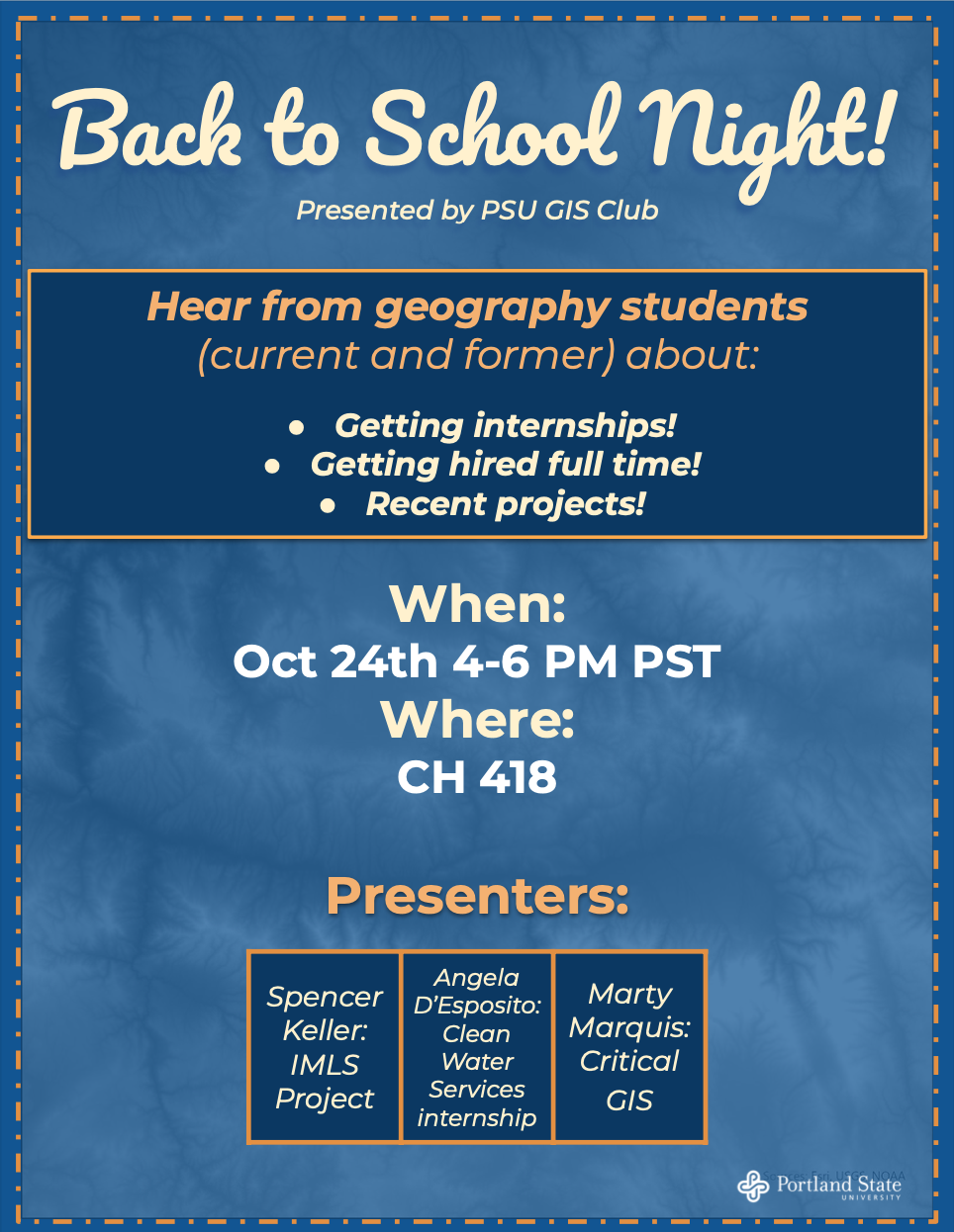 The USGS Cascades Volcano Observatory in Vancouver, Washington, is seeking to fill a science outreach position. This permanent position will be filled as a Physical Scientist at the GS-11 or GS-12 level depending on candidate qualifications. Specific duties of this position include:
The recruitment announcement will open on Wednesday, October 12 and remain open through Monday, October 24 (11:59 pm Eastern Time) or until 70 applications have been received. The announcement number is: USGS-SAC-22-11596792-DE-MB. Applicants can find details of this position, and instructions for application at: https://www.usajobs.gov/GetJob/ViewDetails/682499200 Applicants should pay careful attention to the following:
Additional information regarding the federal hiring process can be found at: https://www.usajobs.gov/Help/ https://www.mygisjobs.com/Job-Listing-GIS-and-Tableau-Specialist-ISS6/166514121730
The Oregon Liquor and Cannabis Commission (OLCC) is hiring a GIS and Tableau Specialist (Information Systems Specialist 6) for the Milwaukie office. This is an exciting opportunity to be a part of a state agency that is the third largest generator of state revenue. In this role, you will get to expand and strengthen the way OLCC uses data and GIS tools to make decisions and policies related to the regulation of alcohol and cannabis in Oregon. We are posting this opportunity as an internal and external recruitment opportunity. Individuals who currently work for the OLCC will be given preference during the application review process. Who are we? The Oregon Liquor and Cannabis Commission (OLCC) is the agency responsible for regulating the sale and service of alcoholic beverages in Oregon by administering the state’s Liquor Control Act and regulating the sale of recreational marijuana in Oregon through the Control, Regulation, and Taxation of Marijuana and Industrial Hemp Act. The agency is comprised of three major operational programs; the Distilled Spirits Program, the Recreational Marijuana Program, and the Public Safety Program. All three programs are supported by the Administration, Financial Services, and Support Services divisions. Revenue generated from these programs helps support state and local government programs. What will you do? You will act as the primary support resource for OLCC’s geographic information system (GIS) as well as a resource for data extraction, analysis, and visualization. This resource will work with various stakeholders both within and outside the agency in supporting staff with location data, development and maintenance of geodatabases; the development of maps, web-based applications, extraction and analysis of data; and other data needs. What are some of the supporting duties? Construction
Operations
Customer Service
What’s in it for you?
What are we looking for? Desired Attributes: Proficiency in Python and/or SQL. What do you need to qualify? Minimum Qualifications: a) Five (5) years of information systems experience in ArcGIS and Tableau; OR b) An Associate's degree in Computer Science, Information Technology, or related field, OR; Completion of a two (2) year accredited vocational training program in information technology or related field; AND Three (3) years of information systems experience in ArcGIS and Tableau; OR c) A Bachelor's degree in Information Technology, Computer Science, or related field AND one (1) year of information systems experience in: ArcGIS and Tableau. Want to know more? Here’s some additional information:
https://www.governmentjobs.com/careers/hillsboro/jobs/3741127/gis-and-asset-management-technician
The City of Hillsboro Hillsboro is one of Oregon’s most diverse and dynamic cities, with a steadily growing population of 108,154 residents. Hillsboro is also the largest city in Washington County and serves as the county seat. We are recognized as a major economic and employment center within the larger Portland metro area and represent the epicenter of the Silicon Forest. We enjoy a reputation for innovation and excellence in our long-term strategic and fiscal planning and we welcome and value each community member, business, and visitor by providing exceptional public services. Like the people we serve, City of Hillsboro employees are passionate about fostering a culturally inclusive community. The Role The City of Hillsboro Public Works Department is looking for an entry-level GIS Technician to join a team of GIS professionals serving the geospatial needs of the City’s Transportation, Stormwater and Sanitary Sewer utilities. This role works both independently and collaboratively with the team in the office and in the field to maintain accurate utility asset inventories. Key duties include as-built digitization, management of GIS edit requests from field staff, operational data updates, and web/paper map production. The GIS and Asset Management Technician roles serves primarily as the one to input data into our existing database structure, edit data where needed to maintain accuracy, and interact with our field crews for edit requests. Global Navigation Satellite System (GNSS) equipment is used on occasion to verify and update utility GIS data. This role is heavily focused on building and improving the accuracy of our data, a critical function that informs our decision makers throughout the City. The Need Successful candidates for the GIS and Asset Management Technician position will be able to effortlessly navigate the technical aspects of the role such as web and paper map production, ArcGIS Pro or ArcMap software, and Computerized Maintenance Management System (CMMS) or asset management software. Simultaneously, this role has a strong internal service component that requires exceptional critical thinking skills to efficiently process an internal customer’s request, interpret their need, and think ahead to deliver a better product than what may have been initially anticipated. Every project is unique, and this role interacts with a variety of internal customers. Possessing the ability to build rapport with internal stakeholders, efficiently manage one’s time to keep up with the ongoing queue of requests along with managing the occasional ad-hoc requests will be crucial to success. Current and Upcoming Projects
Acceptable Experience and Training
Licensing/Certifications
Commitment To Diversity Hiring a workforce that reflects the diverse community we serve is essential to delivering exceptional City services and programs. The City of Hillsboro is committed to creating and supporting an inclusive and welcoming environment for all employees to thrive. We value, respect, and empower employees as unique individuals with authentic voices and diverse ideas. https://www.usajobs.gov/Job/681265400#shorten-link
Summary The Recent Graduates Program affords developmental experiences in the Federal Government intended to promote possible careers in the civil service to individuals who have recently graduated from qualifying educational institutions or programs. Current students who are scheduled to graduate within nine months may also apply to these positions. However, these students cannot be appointed until after graduation and the official degree has been awarded and conferred. Clarification from the agency Recent graduate who has, within the previous two years, completed a qualifying Associate's, Bachelors, Masters, Doctorate, professional, vocational or technical degree or certificate program. Veterans unable to apply within two years of receiving their degree due to military service obligation have up to six years after degree completion to apply. Duties
|
Categories
All
Archives
June 2024
|
 RSS Feed